
The Dutch Safety Board asked MARIN and research institute Deltares to investigate how storm conditions such as those encountered above the Dutch Wadden Islands can lead to Ultra Large Container Ships (ULCS) losing containers.
![]()
On the night of January 1-2, 2019, the ULCS MSC Zoe was sailing eastbound on the southerly route along the Dutch Wadden Islands when she got caught in a north-westerly storm. The ship eventually lost 342 containers during the storm. This led to large-scale pollution of the sea and of the Wadden Islands, which are a UNESCO World Heritage site.
Defining the environmental conditions
Combining simulations and available bathymetric models, Deltares was able to determine the wind, current, water depth and wave conditions along the route. The water depth was estimated to be between 21 and 26 m, considering tidal effects. When the incident happened a north-westerly storm was present over the North Sea, with a wind force up to Beaufort 8 and waves of a significant height of 6.5 m with extreme heights up to 11 m. The wind and wave direction was nearly perpendicular to the route. According to Deltares these storm conditions are not exceptional, occurring once or twice every year in this area.
In comparison with deep waters, the shallow water waves encountered in the area are significantly steeper and exhibit much higher crests. These dangerous waves are well-known to the crews sailing frequently in the area.
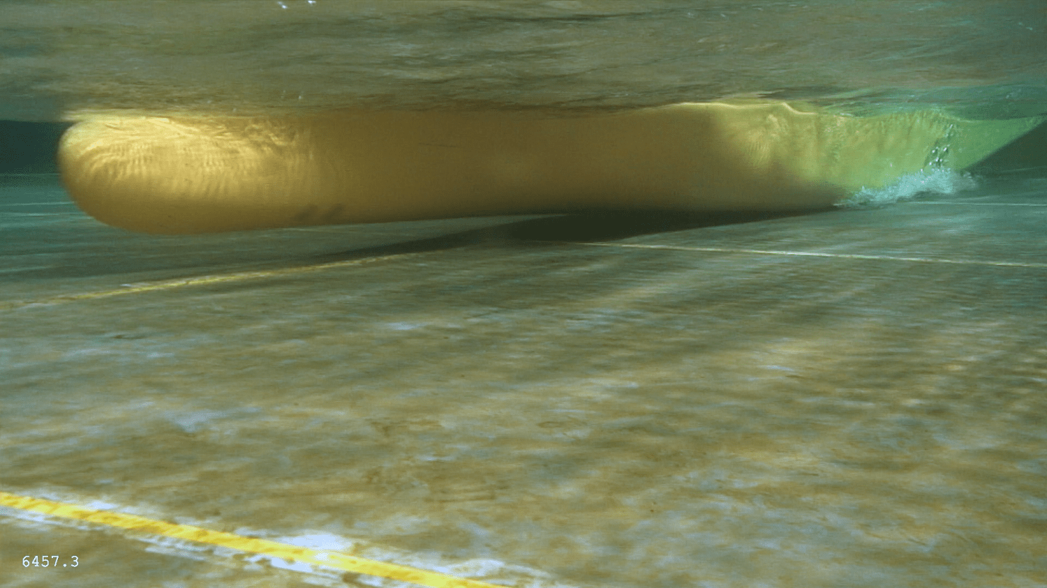
Scale model sailing at 10 kn through 6.5 m high beam waves, water depth 21.3 m
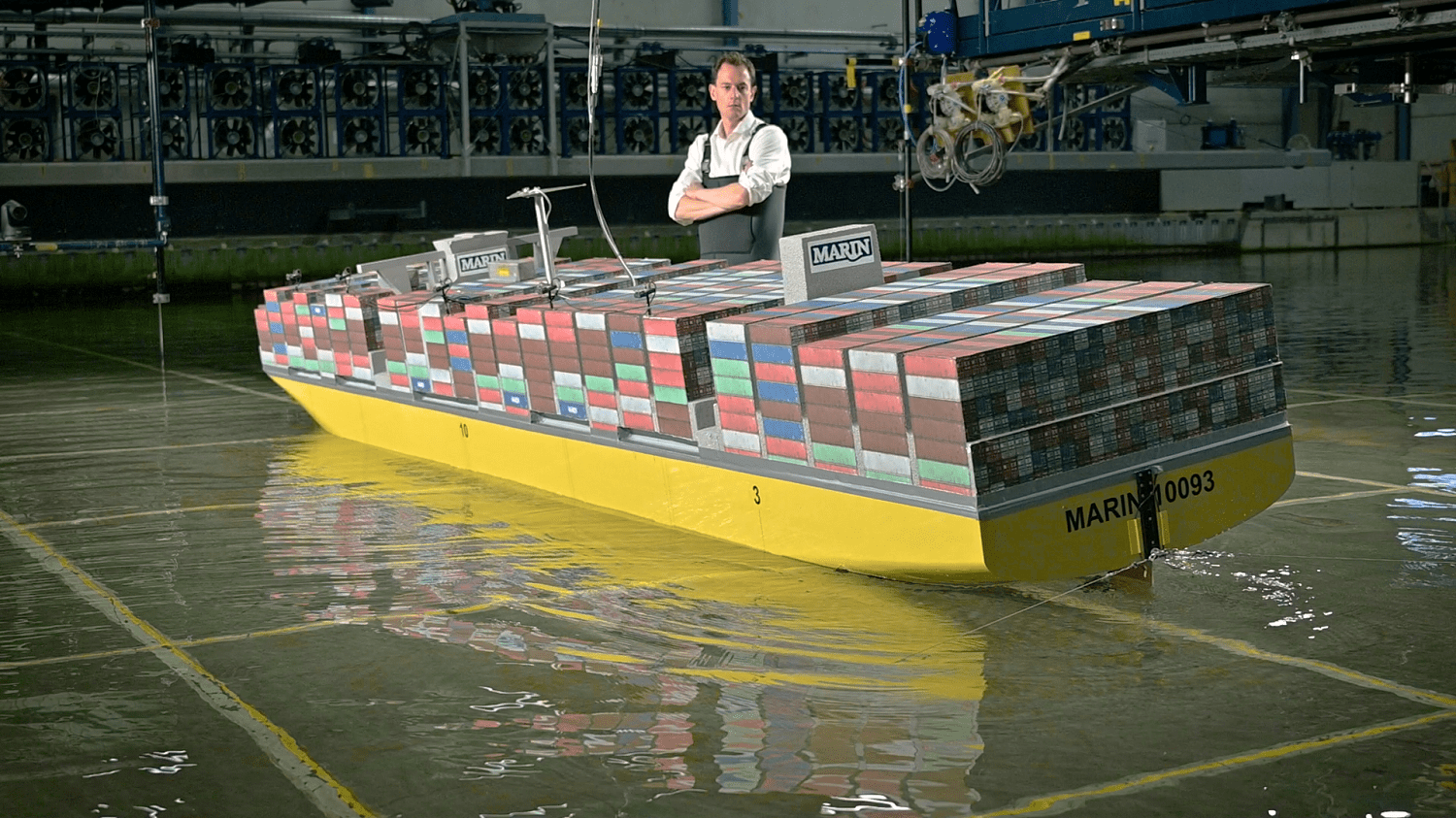
Scaling in our Offshore Basin
These environmental conditions were recreated at a scale of 1 to 63 in MARIN’s Offshore Basin. A special feature of our basin is the movable floor, which made it possible to adjust the water depths to match those encountered on the shipping routes along the Wadden Islands.
Bastien Abeil, Project Manager, explains: “Adjusting the water depth in the basin allowed us to reproduce the wave hydrodynamics that are observed at sea along these shallow routes.” MARIN prepared a scale model of a ULCS similar to the MSC Zoe. Particular attention was given to the loading condition of the model, so that it was representative of a typical vessel of this type. Tests were conducted at different water depths, representing both the southerly and northerly routes which enabled the ship’s behaviour along the two routes to be compared. Additionally, different wave heights were considered, so that the consequences of a more severe storm could be observed. MARIN also did extensive calculations and simulations to broaden the range of ship and wave conditions and talked to nautical specialists who have sailed containerships in this area, he adds.
![]()
Scale model in 6.5 m high beam waves, water depth 21.3 m
Based on these investigations MARIN came to the conclusion that a combination of the following four phenomena could lead to ULCSs losing containers:
1. ULCSs have a very large beam of around 60 m which makes them very stable; when a force is applied to them they will return to their upright equilibrium position relatively quickly. This results in a short natural period during which the ship starts to roll as it is brought into motion by an external force. For the present generation of ULCSs this natural period can be between 15 and 20 seconds, close to the wave periods that occur above the Wadden Islands in such north-westerly storms. As a result, roll resonance may occur, causing heeling angles of 15 to 20 degrees. Such extreme roll amplitudes combined with high ship stability can cause large accelerations and forces being applied to the containers that can exceed safe design values.
2. In these beam waves, ships do not only roll from side to side, but also heave up and down many vertical metres. With a draught of around 12 m in a water depth of only 21 m, there is very limited under keel clearance between the ship and the seabed – actually less than 10 m. As a result of the combined rolling and heaving, wide and deep ULCSs can touch the seabed. When this happens, shocks and vibrations can occur in the ship, containers and lashings.
3. In the very shallow water above the Wadden Islands, breaking waves can hit the side of the ship, resulting in a large upward jet of water reaching the containers, which are 20 to 40 m above the surface of the sea. These enormous volumes of water, also called ‘green water’, hit the bottom and the side of the containers at high velocity, which can lead to substantial damage. Complete stacks of containers can also be pushed over like dominoes. A comparison of the locations on the ship model where green water impacts were observed with those of the damaged bays of containers on the MSC Zoe found that green water impacts may have played a role in the loss of the containers.
4. Finally: the hull of the ship was also hit by breaking waves. This can result in vibrations throughout the ship, damaging containers and lashings.
Under combined heave and roll motions the keel of ULCSs can hit the seabed
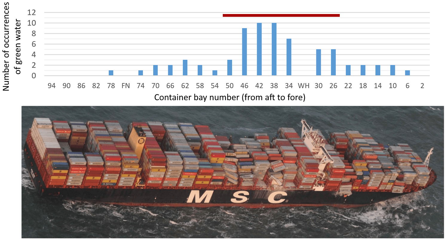
Green water was observed during the tests to occur mostly in the area aft and fore of the wheelhouse, where the MSC Zoe underwent most damage
Further investigations necessary
To prevent this type of disaster from occurring in the future, it is important to look more closely into the matter and consider other ship types and sizes that sail in this busy area. The same four phenomena will occur for smaller ships, but their sensitivity and the limiting weather conditions for safe operations will be different.
Following extensive research and taking into account the annual traffic levels above the Wadden Islands, MARIN advised the Ministry of Infrastructure and Water Management to conduct further investigations into three ship types: ULCSs with lengths of up to 400 m, a shorter and narrower Panamax, nearly 300 m long, and a smaller container feeder with a length of 160 m. The importance of extending the study to the feeder class was confirmed on February 11th 2020, when the 170 m OOCL Rauma lost seven containers while sailing in the same area. “Due to the large array of ship sizes it is essential to take the human factor into consideration. The captain of a feeder shall obviously behave differently than the captain of a ULCS when he gets caught in bad weather,” Bastien emphasises.
MARIN is currently performing studies for both the shallow southerly route directly above the Wadden Islands, as well as the slightly deeper, more northerly route. Based on these results the government can determine what policy is required. For example, this could range from the Coastguard offering advice to ships in the area to the closure of an entire route under certain conditions.
The report of the Dutch Safety Board, the international report and MARIN’s technical report can be found at www.onderzoeksraad.nl/en/page/13223/safe-container-transport-north-of-thewadden-islands.-lessons-learned.